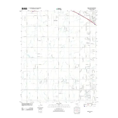
2012 Map of Minco NE
USGS Topo · Published 2012About this map
Forehand Cem and the sprawling Clarence E Page Municipal Airport anchor the northern landscape of this Canadian County area, where suburban expansion meets rural Oklahoma. The terrain is defined by a dendritic network of streams including Purcell Cr, Shell Cr, and Mustang Cr, which dictate the placement of roads and residential developments. In the northeast, the crossing of Highway 40 and Garth Brooks Boulevard marks a significant transition from the grid-patterned countryside toward denser urban fringes. Local water features like Jacobs Acres Lake and Lakehoma Acres Lake reveal the character of modern residential planning in the early 21st century. The map also identifies the small community of Legate, situated along a corridor that connects local agriculture with the developing outskirts of Oklahoma City.
Find a feature on this map
122 named features on this map. Tap any name to fly to it.
Don’t see what you’re looking for? This feature index may not catch every label — zoom into the map to look around manually.
Map Details
Editions of this 2012 Minco NE Map
This is the sole edition of this map. No revisions or reprints were ever made.
Other maps of this area

1892 · Kingfisher
USGS Topo · 1:125,000

1893 · Oklahoma City
USGS Topo · 1:62,500

1893 · Minco
USGS Topo · 1:62,500

1895 · Kingfisher
USGS Topo · 1:125,000

1904 · Chickasha
USGS Topo · 1:125,000

1954 · Oklahoma City
USGS Topo · 1:250,000

1956 · Oklahoma City
USGS Topo · 1:62,500

1957 · Oklahoma City
USGS Topo · 1:250,000

1963 · Oklahoma City
USGS Topo · 1:250,000
1965 · Oklahoma City SW
USGS Topo · 1:24,000