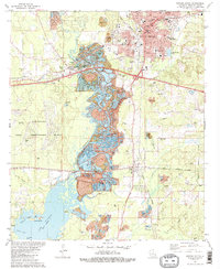
1981 Map of Minden South
USGS Topo · Published 1982About this map
Minden serves as the industrial and civic anchor of this Webster Parish landscape, where the Louisiana and Arkansas and Illinois Central Gulf railroads intersect. To the south and west, the terrain is defined by the wide, marshy corridor of Bayou Dorcheat, which feeds into the northern reaches of Lake Bistineau. This waterway system, dotted with features like Goat Island and Tadpole Lake, highlights the importance of the bayou to the local environment and drainage.
Find a feature on this map
58 named features on this map. Tap any name to fly to it.
Don’t see what you’re looking for? This feature index may not catch every label — zoom into the map to look around manually.
Map Details
Editions of this 1981 Minden South Map
2 editions found
Other maps of this area

1947 · Ringgold
USGS Topo · 1:62,500

1947 · Minden
USGS Topo · 1:62,500

1948 · Jamestown
USGS Topo · 1:62,500

1949 · Jamestown
USGS Topo · 1:62,500

1949 · Minden
USGS Topo · 1:62,500

1949 · Gibsland
USGS Topo · 1:62,500

1950 · Gibsland
USGS Topo · 1:62,500

1955 · Shreveport
USGS Topo · 1:250,000

1956 · Shreveport
USGS Topo · 1:250,000

1956 · Ringgold
USGS Topo · 1:62,500