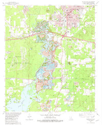
1981 Map of Minden South
USGS Topo · Published 1982About this map
Minden and its southern environs serve as a center for industry and transportation in Webster Parish during the early 1980s. The landscape is defined by the convergence of the Louisiana And Arkansas and Illinois Central Gulf railroads, which facilitated the region's heavy extraction and manufacturing economy. To the west, the Louisiana Army Ammunition Plant occupies a significant portion of the territory, while the central corridor is marked by extensive Gravel Pit operations along the margins of Bayou Dorcheat. This bayou flows southward into Lake Bistineau, where Goat Island and Little Crane Island sit at the northern reaches of the lake. Local genealogy is well-documented through a dense network of country burial grounds, including the Knottingham Cem, Keene Cem, and Overton Cem, many situated near small settlements like Dixie Inn and McIntyre.
Find a feature on this map
62 named features on this map. Tap any name to fly to it.
Don’t see what you’re looking for? This feature index may not catch every label — zoom into the map to look around manually.
Map Details
Editions of this 1981 Minden South Map
2 editions found
Other maps of this area

1947 · Ringgold
USGS Topo · 1:62,500

1947 · Minden
USGS Topo · 1:62,500

1948 · Jamestown
USGS Topo · 1:62,500

1949 · Jamestown
USGS Topo · 1:62,500

1949 · Minden
USGS Topo · 1:62,500

1949 · Gibsland
USGS Topo · 1:62,500

1950 · Gibsland
USGS Topo · 1:62,500

1955 · Shreveport
USGS Topo · 1:250,000

1956 · Shreveport
USGS Topo · 1:250,000

1956 · Ringgold
USGS Topo · 1:62,500