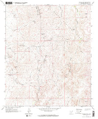
1964 Map of Mineral Mtn
USGS Topo · Published 1971About this map
Hard rock mining operations dominate this desert landscape within the Tonto National Forest, as it was recorded in the early 1960s. The settlement of Reymert (Site) is noted as a site, situated near the Reymert Mine and Reymert Wash. The terrain is characterized by a complex network of steep canyons, including Box Canyon, Martinez Canyon, and Alamo Canyon, which dictated the placement of mining claims and access routes.
Find a feature on this map
34 named features on this map. Tap any name to fly to it.
Don’t see what you’re looking for? This feature index may not catch every label — zoom into the map to look around manually.
Map Details
Editions of this 1964 Mineral Mtn Map
3 editions found
Other maps of this area

1900 · Florence
USGS Topo · 1:125,000

1902 · Florence
USGS Topo · 1:125,000

1948 · Superior
USGS Topo · 1:62,500

1948 · Superior
USGS Topo · 1:24,000

1948 · Picketpost Mtn
USGS Topo · 1:24,000

1949 · Superior
USGS Topo · 1:24,000

1949 · Picketpost Mtn
USGS Topo · 1:24,000

1954 · Mesa
USGS Topo · 1:250,000

1957 · Mesa
USGS Topo · 1:250,000

1958 · Mesa
USGS Topo · 1:250,000