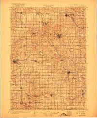
1902 Map of Mineral Point
USGS Topo · Published 1917About this map
The driftless area of Southwest Wisconsin and Northern Illinois is defined by its dendritic river networks and lead-mining history, long before the modern landscape was fully settled. Mineral Point and Dodgeville serve as major hubs connected by a web of early rail lines, including the Chicago and Northwestern RR and the Illinois Central RR. The topography is marked by the distinctive Platte Mounds and the winding course of the Pecatonica River, which gathers numerous tributaries like the Ames Branch and Wood Branch as it flows south toward the Illinois border.
Find a feature on this map
99 named features on this map. Tap any name to fly to it.
Don’t see what you’re looking for? This feature index may not catch every label — zoom into the map to look around manually.
Map Details
Editions of this 1902 Mineral Point Map
4 editions found
Other maps of this area

1900 · Lancaster
USGS Topo · 1:125,000

1901 · Peosta
USGS Topo · 1:125,000

1902 · Mineral Point
USGS Topo · 1:125,000

1904 · Lancaster
USGS Topo · 1:125,000

1905 · Richland Center
USGS Topo · 1:125,000

1908 · Lancaster
USGS Topo · 1:125,000

1911 · Elizabeth
USGS Topo · 1:62,500

1911 · Galena
USGS Topo · 1:62,500

1913 · Galena
USGS Topo · 1:62,500

1920 · Blue Mounds
USGS Topo · 1:62,500