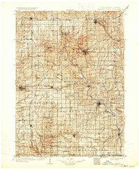
1902 Map of Mineral Point
USGS Topo · Published 1933About this map
The Mineral Point and Dodgeville districts of southwest Wisconsin are defined by a dense network of early 20th-century railroads and river valleys during this 1902 survey. Major lines including the Chicago Milwaukee and St Paul and the Mineral Point and Northern weave between established mining and agricultural hubs like Shullsburg, Belmont, and Platteville. The terrain is punctuated by the prominent Platte Mounds and drained by the serpentine paths of the Pecatonica River and the Galena River. The map captures a landscape transitioning toward industrial maturity, where small junctions like Calamine and Ipswich served as vital links for moving lead, zinc, and agricultural goods. Notable settlements such as Mifflin, Linden, and Gratiot reflect the settled rural character of the driftless area before modern highway expansion altered the traditional rail-and-river transport patterns.
Find a feature on this map
99 named features on this map. Tap any name to fly to it.
Don’t see what you’re looking for? This feature index may not catch every label — zoom into the map to look around manually.
Map Details
Editions of this 1902 Mineral Point Map
4 editions found
Other maps of this area

1900 · Lancaster
USGS Topo · 1:125,000

1901 · Peosta
USGS Topo · 1:125,000

1902 · Mineral Point
USGS Topo · 1:125,000

1904 · Lancaster
USGS Topo · 1:125,000

1905 · Richland Center
USGS Topo · 1:125,000

1908 · Lancaster
USGS Topo · 1:125,000

1911 · Elizabeth
USGS Topo · 1:62,500

1911 · Galena
USGS Topo · 1:62,500

1913 · Galena
USGS Topo · 1:62,500

1920 · Blue Mounds
USGS Topo · 1:62,500