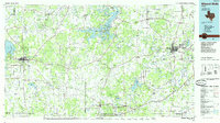
1985 Map of Mineral Wells
USGS Topo · Published 1985About this map
The Brazos River winds through the heart of north-central Texas in this mid-1980s compilation, anchoring a landscape defined by significant water management and rural industry. Large reservoirs like Possum Kingdom Lake and Hubbard Creek Lake dominate the hydrography, surrounded by the varied elevations of the Caddo Mountains and Palo Pinto Mountains. The mapping shows the established urban centers of Mineral Wells and Breckenridge, connected by a network of roads and the Missouri Pacific railroad corridor.
Find a feature on this map
82 named features on this map. Tap any name to fly to it.
Don’t see what you’re looking for? This feature index may not catch every label — zoom into the map to look around manually.
Map Details
Editions of this 1985 Mineral Wells Map
2 editions found
Other maps of this area

1889 · Granbury
USGS Topo · 1:125,000

1890 · Stephenville
USGS Topo · 1:125,000

1890 · Breckenridge
USGS Topo · 1:125,000

1891 · Weatherford
USGS Topo · 1:125,000

1891 · Palo Pinto
USGS Topo · 1:125,000

1892 · Albany
USGS Topo · 1:125,000

1893 · Albany
USGS Topo · 1:125,000

1893 · Weatherford
USGS Topo · 1:125,000

1894 · Eastland
USGS Topo · 1:125,000

1918 · Palo Pinto
USGS Topo · 1:125,000