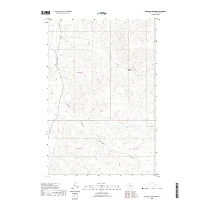
2020 Map of Minnehaha Creek North
USGS Topo · Published 2020About this map
Sarpy Creek flows northward through this rural Treasure County landscape, defining a drainage system that includes Outlaw Coulee and Outlaw Spring. The topography is characterized by a network of seasonal watercourses and ridges, where the namesake Minnehaha Creek joins a broader system of tributaries. Local transit is rooted in the early ranching and agricultural framework of the region, marked by gravel and dirt routes such as Sarpy Road and Beaver Creek Road. The map documents a sparsely populated area where the economy is tied to the land and its water sources, including Bear Creek and Sawmill Coulee. This 2020 survey provides a modern record of the township and range divisions, specifically t4n r37e and t3n r38e, preserving the contemporary configuration of property access and natural drainage in the Montana interior.
Find a feature on this map
23 named features on this map. Tap any name to fly to it.
Don’t see what you’re looking for? This feature index may not catch every label — zoom into the map to look around manually.
Map Details
Editions of this 2020 Minnehaha Creek North Map
This is the sole edition of this map. No revisions or reprints were ever made.
Other maps of this area

1954 · Hardin
USGS Topo · 1:250,000

1954 · Forsyth
USGS Topo · 1:250,000

1957 · Hardin
USGS Topo · 1:250,000

1957 · Forsyth
USGS Topo · 1:250,000

1958 · Forsyth
USGS Topo · 1:250,000

1958 · Hardin
USGS Topo · 1:250,000

1971 · Mc Clure Creek
USGS Topo · 1:24,000

1971 · Griffin Coulee SW
USGS Topo · 1:24,000
1971 · Griffin Coulee NW
USGS Topo · 1:24,000

1972 · Minnehaha Creek South
USGS Topo · 1:24,000