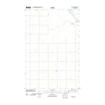
2011 Map of Minot NW
USGS Topo · Published 2011About this map
Ralston and Drady anchor the agricultural landscape of Ward County in this 2011 survey, showing the persistent grid of the Great Plains. The Souris River cuts through the northeast corner, creating a distinct topographical break from the surrounding plateau. This waterway, along with its tributaries South Branch Coulee and Gassman Coulee, defines the drainage patterns and valley formations in an otherwise uniform section of North Dakota. The map meticulously documents a dense network of range and township roads, such as 4th Ave NW and 93rd Ave SW, which provide access to the dispersed farmsteads and rural properties characteristic of the region. The transition between 128th St NW and 128th St SW marks the north-south dividing line of the local survey system, illustrating the precise geometry used to organize the territory.
Find a feature on this map
23 named features on this map. Tap any name to fly to it.
Don’t see what you’re looking for? This feature index may not catch every label — zoom into the map to look around manually.
Map Details
Editions of this 2011 Minot NW Map
This is the sole edition of this map. No revisions or reprints were ever made.
Other maps of this area

1928 · Minot
USGS Topo · 1:62,500

1948 · Burlington
USGS Topo · 1:24,000

1948 · Burlington
USGS Topo · 1:62,500

1948 · Minot NW
USGS Topo · 1:24,000

1949 · Minot NW
USGS Topo · 1:24,000

1949 · Burlington SE
USGS Topo · 1:24,000

1949 · Minot
USGS Topo · 1:24,000

1950 · Des Lacs
USGS Topo · 1:24,000
1950 · Burlington
USGS Topo · 1:24,000
1951 · Burlington
USGS Topo · 1:62,500