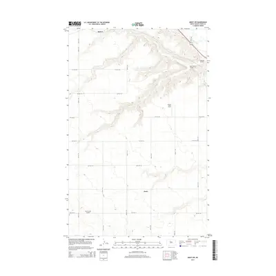
2014 Map of Minot NW
USGS Topo · Published 2014About this map
Drady and Ralston stand as primary reference points in this northern Ward County landscape, where the prairie is deeply incised by a series of drainage coulees. The Souris River winds through the northeastern corner of the map, fed by the Gassman Coulee and its South Branch. These geographic features dictate the local road grid, which navigates the elevations between the river valley and the higher plains. Notable for local aviation history and transport, the Flying S Ranch Airport is situated on the plateau between the major coulees. In the southwest, the First Larson Coulee marks another significant break in the terrain. This survey reflects the modern agricultural and rural layout of the region, emphasizing the persistence of small named locales and ranching infrastructure within the traditional township-and-range section system.
Find a feature on this map
20 named features on this map. Tap any name to fly to it.
Don’t see what you’re looking for? This feature index may not catch every label — zoom into the map to look around manually.
Map Details
Editions of this 2014 Minot NW Map
This is the sole edition of this map. No revisions or reprints were ever made.
Other maps of this area

1928 · Minot
USGS Topo · 1:62,500

1948 · Burlington
USGS Topo · 1:24,000

1948 · Burlington
USGS Topo · 1:62,500

1948 · Minot NW
USGS Topo · 1:24,000

1949 · Minot NW
USGS Topo · 1:24,000

1949 · Burlington SE
USGS Topo · 1:24,000

1949 · Minot
USGS Topo · 1:24,000

1950 · Des Lacs
USGS Topo · 1:24,000
1950 · Burlington
USGS Topo · 1:24,000
1951 · Burlington
USGS Topo · 1:62,500