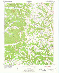
1953 Map of Mintonville
USGS Topo · Published 1976About this map
The boundary between Casey and Pulaski Counties runs through a landscape of high ridges and rural settlements in the early 1950s. Mintonville and Argyle serve as central nodes for a network of country schools and churches that reflect a deeply rooted community structure. Distinctive landmarks like Green River Knob and Spaw Knob rise above the complex drainage patterns of Jonathan Fork and Fishing Creek. Local educational sites including the Chuckuluck Sch and Chestnut Level Sch are documented alongside family-named ridges like Vaught Ridge and Hickory Ridge. This survey reveals the agricultural layout of the region before significant modernization, showing a high density of small-scale infrastructure such as the Watson Chapel and various mountain cemeteries that are invaluable for genealogical research.
Find a feature on this map
71 named features on this map. Tap any name to fly to it.
Don’t see what you’re looking for? This feature index may not catch every label — zoom into the map to look around manually.
Map Details
Editions of this 1953 Mintonville Map
3 editions found
Other maps of this area

1935 · Somerset
USGS Topo · 1:62,500

1952 · Eubank
USGS Topo · 1:24,000

1952 · Liberty
USGS Topo · 1:24,000

1952 · Yosemite
USGS Topo · 1:24,000

1953 · Phil
USGS Topo · 1:24,000

1953 · Mintonville
USGS Topo · 1:24,000

1954 · Delmer
USGS Topo · 1:24,000

1954 · Science Hill
USGS Topo · 1:24,000

1954 · Eli
USGS Topo · 1:24,000
1954 · Faubush
USGS Topo · 1:24,000