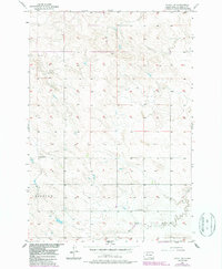
1956 Map of Miscol SW
USGS Topo · Published 1987About this map
Standing Rock Indian Reservation land defines the landscape of this mid-century survey, which reveals a sparsely populated prairie environment focused on isolated rural community hubs. The map identifies the township of Fairview, where long-standing educational landmarks like Lone Tree Sch and Little Oak Sch served the local ranching families. The terrain is primarily shaped by the meandering course of High Bank Creek, which provides the primary drainage through the rolling hills. This 1956 field check, updated with mid-1980s aerial data, captures the enduring agricultural patterns of Fairview before more modern infrastructure arrived, offering a clear record for those tracing land allotments or family school districts in the Miscol area.
Find a feature on this map
5 named features on this map. Tap any name to fly to it.
Don’t see what you’re looking for? This feature index may not catch every label — zoom into the map to look around manually.
Map Details
Editions of this 1956 Miscol SW Map
3 editions found
Other maps of this area

1953 · McIntosh
USGS Topo · 1:250,000

1956 · Miscol SW
USGS Topo · 1:24,000

1956 · Black Horse NE
USGS Topo · 1:24,000

1956 · Black Horse SE
USGS Topo · 1:24,000

1956 · Miscol SE
USGS Topo · 1:24,000

1956 · Miscol
USGS Topo · 1:24,000

1956 · Miscol NE
USGS Topo · 1:24,000

1958 · McIntosh
USGS Topo · 1:250,000

1978 · Brewer Butte
USGS Topo · 1:24,000

1978 · Timber Lake
USGS Topo · 1:24,000