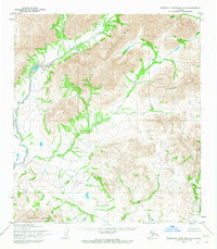
1955 Map of Misheguk Mountain A-3
USGS Topo · Published 1976About this map
The Misheguk Mountains dominate this high-latitude Alaskan landscape, showing a region defined by complex drainage patterns and unsurveyed land lines. Mapped by the Army Map Service in the mid-1950s, the terrain transitions through several distinct ranges including the Kingasivik Mountains and the Isacheluich Mountains. The hydrological network is the primary guiding feature for navigation here, with the Kaluktavik River and Imikneyak Creek carving through the mountain passes.
Find a feature on this map
8 named features on this map. Tap any name to fly to it.
Don’t see what you’re looking for? This feature index may not catch every label — zoom into the map to look around manually.
Map Details
Editions of this 1955 Misheguk Mountain A-3 Map
2 editions found
Other maps of this area

1951 · Baird Mountains
USGS Topo · 1:250,000

1951 · Misheguk Mountain
USGS Topo · 1:250,000

1955 · Baird Mountains D-4
USGS Topo · 1:63,360

1955 · Baird Mountains D-3
USGS Topo · 1:63,360

1955 · Misheguk Mountain A-3
USGS Topo · 1:63,360
1955 · Misheguk Mountain A-4
USGS Topo · 1:63,360

1956 · Misheguk Mountain
USGS Topo · 1:250,000

1956 · Baird Mountains
USGS Topo · 1:250,000

1965 · Baird Mountains
USGS Topo · 1:250,000
1990 · Misheguk Mountain B-2
USGS Topo · 1:63,360