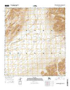
2015 Map of Misheguk Mountain A-4 NW
USGS Topo · Published 2015About this map
Noatak National Preserve encompasses a significant portion of this Arctic landscape, where the terrain rises sharply toward the northeast corner. Dominating the high ground is Misheguk Mtn, a prominent peak that serves as a primary landmark in the Northwest Arctic Borough. Below the higher elevations, the drainage network is defined by the winding paths of Trail Creek and Okotak Creek, which cut through the tundra. The map shows the Public Land Survey System divisions, including t33n r12w, t33n r11w, t32n r12w, and t32n r11w, illustrating the underlying grid applied to this remote wilderness. The lack of roads or established settlements emphasizes the undisturbed character of this northern watershed within the national preserve system.
Find a feature on this map
8 named features on this map. Tap any name to fly to it.
Don’t see what you’re looking for? This feature index may not catch every label — zoom into the map to look around manually.
Map Details
Editions of this 2015 Misheguk Mountain A-4 NW Map
This is the sole edition of this map. No revisions or reprints were ever made.
Other maps of this area

1951 · Misheguk Mountain
USGS Topo · 1:250,000

1955 · Misheguk Mountain A-5
USGS Topo · 1:63,360
1955 · Misheguk Mountain A-4
USGS Topo · 1:63,360

1956 · Misheguk Mountain
USGS Topo · 1:250,000
1990 · Misheguk Mountain B-5
USGS Topo · 1:63,360
1990 · Misheguk Mountain B-4
USGS Topo · 1:63,360
2014 · Misheguk Mountain B-5 SE
USGS Topo · 1:25,000

2015 · Misheguk Mountain A-4 NE
USGS Topo · 1:25,000
2015 · Misheguk Mountain A-5 SE
USGS Topo · 1:25,000
2015 · Misheguk Mountain B-4 SW
USGS Topo · 1:25,000