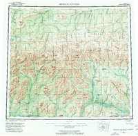
1956 Map of Misheguk Mountain
USGS Topo · Published 1977About this map
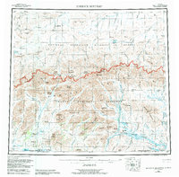
Brooks Range peaks and the upper reaches of the Noatak River define this expansive Alaskan wilderness. The map documents a time when access relied heavily on a Winter Trail stretching across the northern tundra and a scattered Landing Area for bush pilots. A lone Cabin near Noluck Lake provides one of the few signs of human habitation in a landscape characterized by dramatic landforms like Rabbit Ears and Copter Peak. Much of the northern terrain falls within the Naval Petroleum Reserve No 4, reflecting the era's strategic focus on arctic resource potential. From the Misheguk Mountain massif to the complex drainage of the Utukok River, the sheet records the Indigenous and descriptive nomenclature of the region's ridges and passes, including Natinakunit Pass and the Imikneyak Mountains.
Find a feature on this map
89 named features on this map. Tap any name to fly to it.
Don’t see what you’re looking for? This feature index may not catch every label — zoom into the map to look around manually.
Map Details
Editions of this 1956 Misheguk Mountain Map
7 editions found

Other maps of this area

1951 · De Long Mountains
USGS Topo · 1:250,000

1951 · Baird Mountains
USGS Topo · 1:250,000

1951 · Utukok River
USGS Topo · 1:250,000

1951 · Noatak
USGS Topo · 1:250,000

1951 · Lookout Ridge
USGS Topo · 1:250,000

1951 · Point Lay
USGS Topo · 1:250,000

1951 · Howard Pass
USGS Topo · 1:250,000

1951 · Ambler River
USGS Topo · 1:250,000

1951 · Misheguk Mountain
USGS Topo · 1:250,000

1955 · Noatak
USGS Topo · 1:250,000