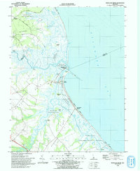
1993 Map of Mispillion River
USGS Topo · Published 1993About this map
The Mispillion River serves as the focal point for this coastal Delaware landscape, marking the boundary between Kent and Sussex Counties. Along the shoreline of the Delaware Bay, the map reveals a history of maritime activity and coastal defense, most notably at the site of Fort Saulsbury. The transition from river to bay is guided by the Mispillion Light and a system of Jetties, while the low-lying marshes are preserved within the Milford Neck State Wildlife Area and Prime Hook National Wildlife Refuge.
Find a feature on this map
37 named features on this map. Tap any name to fly to it.
Don’t see what you’re looking for? This feature index may not catch every label — zoom into the map to look around manually.
Map Details
Editions of this 1993 Mispillion River Map
This is the sole edition of this map. No revisions or reprints were ever made.
Other maps of this area

1890 · Maurice Cove
USGS Topo · 1:62,500

1891 · Maurice Cove
USGS Topo · 1:62,500

1899 · Vineland
USGS Topo · 1:125,000

1918 · Cedar Creek
USGS Topo · 1:62,500

1918 · Cape Henlopen
USGS Topo · 1:62,500

1919 · Cedar Creek
USGS Topo · 1:62,500

1919 · Vineland
USGS Topo · 1:125,000

1934 · Bowers
USGS Topo · 1:48,000
1936 · Bowers
USGS Topo · 1:62,500

1937 · Cape Henlopen
USGS Topo · 1:62,500