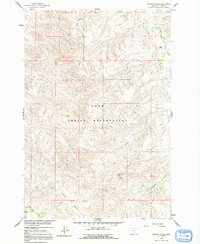
1960 Map of Mission Coulee
USGS Topo · Published 1992About this map
The Crow Indian Reservation landscape is defined by an intricate network of drainage channels and high plateaus in Big Horn County. This 1960 field-checked survey reveals a land utilized primarily for ranching, where the limited water supply dictates the location of human activity. The presence of Siemion Ranch near the winding course of Rotten Grass Creek and Wolf Ranch in the southern reaches demonstrates the isolated nature of these mid-century operations. The topography is dominated by dramatic elevation changes, notably at Rattlesnake Butte, which overlooks a series of deep ravines like Mission Coulee and Ash Coulee. Farther south, the Cooper Basin serves as a distinct natural catchment area. These features reflect the geomorphology of the Missouri River Basin, where ephemeral streams like Dry Soap Creek have carved a complex relief into the high plains.
Find a feature on this map
16 named features on this map. Tap any name to fly to it.
Don’t see what you’re looking for? This feature index may not catch every label — zoom into the map to look around manually.
Map Details
Editions of this 1960 Mission Coulee Map
2 editions found
Other maps of this area

1894 · St. Xavier
USGS Topo · 1:125,000

1901 · St. Xavier
USGS Topo · 1:125,000

1954 · Hardin
USGS Topo · 1:250,000

1957 · Hardin
USGS Topo · 1:250,000

1958 · Hardin
USGS Topo · 1:250,000

1960 · Schick Ranch
USGS Topo · 1:24,000

1960 · St Xavier
USGS Topo · 1:24,000

1960 · St Xavier NE
USGS Topo · 1:24,000

1960 · Mission Coulee
USGS Topo · 1:24,000
1964 · Mountain Pocket Creek
USGS Topo · 1:24,000