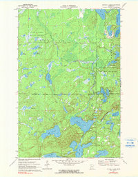
1970 Map of Mitchell Lake
USGS Topo · Published 1980About this map
Land O' Lakes State Forest covers a significant portion of this northern Minnesota landscape, where the boundary between Cass and Crow Wing counties meets the corporate limits of Fifty Lakes and Emily. The area is defined by an intricate network of water bodies and marshlands, including the centrally located Pistol Lake and the southern cluster of Mitchell Lake, Kego Lake, and East Fox Lake. The terrain exhibits the classic post-glacial topography of the region, with Daggett Brook and Hay Creek winding through dense forest and wetlands. Historically, this 1970 snapshot records the early development of these lakeside communities before extensive modern expansion, highlighting localized landmarks such as The Narrows and a Gravel Pit near the eastern margin. The map provides a detailed view of the varied shoreline and the numerous smaller ponds like West Dog Lake and Minnie Lake that comprise this lake country.
Find a feature on this map
32 named features on this map. Tap any name to fly to it.
Don’t see what you’re looking for? This feature index may not catch every label — zoom into the map to look around manually.
Map Details
Editions of this 1970 Mitchell Lake Map
2 editions found
Other maps of this area

1913 · Cuyuna
USGS Topo · 1:62,500

1915 · Cuyuna
USGS Topo · 1:62,500

1953 · Duluth
USGS Topo · 1:250,000

1953 · Brainerd
USGS Topo · 1:250,000

1957 · Brainerd
USGS Topo · 1:250,000

1958 · Brainerd
USGS Topo · 1:250,000

1958 · Duluth
USGS Topo · 1:250,000

1959 · Lower Whitefish Lake
USGS Topo · 1:24,000

1960 · Cross Lake
USGS Topo · 1:24,000

1965 · Brainerd
USGS Topo · 1:250,000