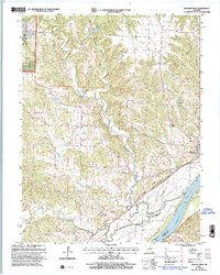
2000 Map of Mokane East
USGS Topo · Published 2003About this map
The Missouri River corridor in Callaway County is defined by its dramatic transition from the forested ridges of the Mark Twain National Forest to the wide alluvial plains where St Aubert Island sits. This landscape preserves the traces of early riverfront development and the transition from rail transport to recreational use along the Katy Trail State Park, which follows the former rail grade along the northern bank. The town of Mokane serves as a primary hub, while scattered rural landmarks such as Mt Tabor Cem and Riverview Cem offer grounding for local genealogical research.
Find a feature on this map
25 named features on this map. Tap any name to fly to it.
Don’t see what you’re looking for? This feature index may not catch every label — zoom into the map to look around manually.
Map Details
Editions of this 2000 Mokane East Map
This is the sole edition of this map. No revisions or reprints were ever made.
Other maps of this area

1890 · Fulton
USGS Topo · 1:125,000

1928 · Fulton
USGS Topo · 1:62,500

1931 · Fulton
USGS Topo · 1:62,500

1935 · Morrison
USGS Topo · 1:48,000

1940 · Montgomery City
USGS Topo · 1:62,500

1942 · Montgomery City
USGS Topo · 1:62,500

1942 · Morrison
USGS Topo · 1:62,500

1945 · Mokane
USGS Topo · 1:62,500

1945 · Morrison
USGS Topo · 1:62,500

1949 · Saint Louis
USGS Topo · 1:250,000