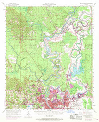
1969 Map of Monroe North
USGS Topo · Published 1969About this map
The Quachita River winds through the heart of this North Louisiana landscape, where the urban expansion of Monroe and West Monroe meets the sprawling wetlands of the Chauvin Swamp. This late-1960s revision captures a critical period of academic and civic growth, highlighting the campus of Northeast Louisiana State College alongside essential local infrastructure like the Sanatorium and the Fish Hatchery. The map reveals a complex water system managed by Lock and Dam No 4 and the Bayou de Siard Dam, which helps regulate the expansive Black Bayou Lake.
Find a feature on this map
94 named features on this map. Tap any name to fly to it.
Don’t see what you’re looking for? This feature index may not catch every label — zoom into the map to look around manually.
Map Details
Editions of this 1969 Monroe North Map
This is the sole edition of this map. No revisions or reprints were ever made.
Other maps of this area

1935 · Collinston
USGS Topo · 1:62,500

1935 · Naff
USGS Topo · 1:62,500

1935 · Alto
USGS Topo · 1:62,500

1935 · Drew
USGS Topo · 1:62,500

1935 · Haile
USGS Topo · 1:62,500

1940 · Monroe
USGS Topo · 1:62,500

1952 · Calhoun
USGS Topo · 1:62,500

1952 · Farmerville
USGS Topo · 1:62,500

1953 · Chatham
USGS Topo · 1:62,500

1955 · Jackson
USGS Topo · 1:250,000