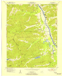
1950 Map of Mont
USGS Topo · Published 1954About this map
Between the Rivers, the narrow strip of land separating the Cumberland River and the Tennessee Valley, is defined here by the Kentucky Woodlands Wildlife Refuge. This mid-century survey captures a landscape of transitioning industry and conservation, where the Center Furnace (Ruins) stands as a reminder of earlier iron production near Hematite Lake. The terrain is characterized by a series of hollows, such as Curry Hollow and Racetrack Hollow, which drain toward the Cumberland’s long shoreline.
Find a feature on this map
53 named features on this map. Tap any name to fly to it.
Don’t see what you’re looking for? This feature index may not catch every label — zoom into the map to look around manually.
Map Details
Editions of this 1950 Mont Map
2 editions found
Other maps of this area

1908 · Princeton
USGS Topo · 1:62,500

1910 · Princeton
USGS Topo · 1:62,500

1928 · Eddyville
USGS Topo · 1:48,000

1931 · Eddyville
USGS Topo · 1:62,500

1936 · Eddyville
USGS Topo · 1:48,000

1936 · Mont
USGS Topo · 1:24,000

1936 · Fenton
USGS Topo · 1:24,000

1936 · Grand Rivers
USGS Topo · 1:24,000

1936 · Hiatt
USGS Topo · 1:24,000

1936 · Birmingham
USGS Topo · 1:24,000