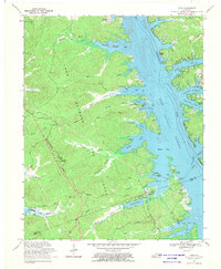
1967 Map of Mont
USGS Topo · Published 1970About this map
The peninsula of Land Between the Lakes is defined by the massive impoundments of the Cumberland River and Tennessee River during the mid-1960s. This survey records a landscape in transition, where legacy features of the 19th-century iron industry like the Center Furnace (Ruins) and family-named landmarks sit alongside new recreation infrastructure. The interior is crossed by the Tennessee Divide Trail and the Scout Trail, connecting historic sites such as Woodson Chapel and the Hematite Ch near the shores of Hematite Lake. The eastern shoreline along Lake Barkley retains the names of older river points like Commerce Landing and Ingram Shoals, while the northern section near Mammoth Furnace Bay preserves the memory of the area's industrial heritage before it became a national recreation area.
Find a feature on this map
63 named features on this map. Tap any name to fly to it.
Don’t see what you’re looking for? This feature index may not catch every label — zoom into the map to look around manually.
Map Details
Editions of this 1967 Mont Map
2 editions found
Other maps of this area

1908 · Princeton
USGS Topo · 1:62,500

1910 · Princeton
USGS Topo · 1:62,500

1928 · Eddyville
USGS Topo · 1:48,000

1931 · Eddyville
USGS Topo · 1:62,500

1936 · Eddyville
USGS Topo · 1:48,000

1936 · Mont
USGS Topo · 1:24,000

1936 · Fenton
USGS Topo · 1:24,000

1936 · Grand Rivers
USGS Topo · 1:24,000

1936 · Hiatt
USGS Topo · 1:24,000

1936 · Birmingham
USGS Topo · 1:24,000