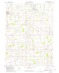
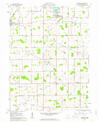
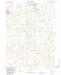
1961 Map of Montezuma
USGS Topo · Published 1975About this map
Coldwater and Montezuma anchor this Mercer County landscape, where the agricultural grid of Western Ohio is punctuated by early 1970s infrastructure updates. The village of Montezuma sits at the edge of Grand Lake, adjacent to Grand State Lake Park and the St Marys Wildlife Area, while Coldwater shows its industrial character with a Sewage Disposal facility and connections to the Norfolk and Western and Penn Central railroads. The map reveals a deeply rooted Catholic heritage through the presence of St Charles Seminary and rural parishes like St Aloysius Ch. Researchers will find numerous family-named roads and burial grounds, including the Burntwood Cem and Long Cem, interspersed among gas wells and local landmarks like the Drive-in Theater near Cassella. The southern boundary follows the Huwer Treaty Line Road, a remnant of early surveying and land agreements.
Find a feature on this map
69 named features on this map. Tap any name to fly to it.
Don’t see what you’re looking for? This feature index may not catch every label — zoom into the map to look around manually.
Map Details
Editions of this 1961 Montezuma Map
Other maps of this area

1908 · St. Henry
USGS Topo · 1:62,500

1909 · Loramie
USGS Topo · 1:62,500

1911 · Loramie
USGS Topo · 1:62,500

1911 · Spencerville
USGS Topo · 1:62,500

1914 · Celina
USGS Topo · 1:62,500

1944 · Loramie
USGS Topo · 1:62,500

1944 · Celina
USGS Topo · 1:62,500

1944 · Spencerville
USGS Topo · 1:62,500

1953 · Muncie
USGS Topo · 1:250,000

1956 · Muncie
USGS Topo · 1:250,000