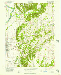
1955 Map of Montezuma
USGS Topo · Published 1957About this map
Montezuma sits prominently along the eastern bank of the Wabash River, serving as a central hub for the region's transportation and industry in the mid-1950s. The landscape is defined by the significant path of the Old Indian Treaty Boundary, which cuts diagonally across the terrain, marking an older era of land division. This survey captures a mix of agricultural and industrial activity, including strip mines near West Union and kilns at Bloomingdale. The Baltimore and Ohio railroad provides a critical artery through the center of the sheet, connecting smaller communities like Klondyke and Coloma. To the north, Sugar Creek winds through the topography, while local religious and community life is anchored by landmarks like Linebarger Chapel and Friends Ch. The presence of both a U S Military Reservation and a U S Air Force Reservation underscores the strategic importance of the river corridor during this period.
Find a feature on this map
37 named features on this map. Tap any name to fly to it.
Don’t see what you’re looking for? This feature index may not catch every label — zoom into the map to look around manually.
Map Details
Editions of this 1955 Montezuma Map
2 editions found
Other maps of this area

1948 · Wallace
USGS Topo · 1:24,000

1951 · Clinton
USGS Topo · 1:24,000

1951 · Mecca
USGS Topo · 1:24,000

1952 · Catlin
USGS Topo · 1:24,000

1953 · Indianapolis
USGS Topo · 1:250,000

1955 · Rockville
USGS Topo · 1:24,000

1955 · Kingman
USGS Topo · 1:24,000

1955 · Montezuma
USGS Topo · 1:24,000

1955 · Dana
USGS Topo · 1:24,000
1955 · Newport
USGS Topo · 1:24,000