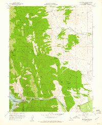
1959 Map of Monticello Dam
USGS Topo · Published 1961About this map
Monticello Dam stands as the defining engineering feat of this 1959 landscape, holding back the waters of Lake Berryessa where the Putah Creek once flowed freely through the canyon. The transition from the steep, brush-covered slopes of the Vaca Mountains and Rocky Ridge to the alluvial plains of the Sacramento Valley is immediate. These eastern flats are marked by historical land divisions like the Rio De Los Putos grant, where drainage is managed through systems like Chickahominy Slough and Union School Slough.
Find a feature on this map
48 named features on this map. Tap any name to fly to it.
Don’t see what you’re looking for? This feature index may not catch every label — zoom into the map to look around manually.
Map Details
Editions of this 1959 Monticello Dam Map
4 editions found
Other maps of this area

1902 · Napa
USGS Topo · 1:125,000

1905 · Esparto
USGS Topo · 1:24,000

1907 · Woodland
USGS Topo · 1:62,500

1908 · Vacaville
USGS Topo · 1:62,500

1916 · Jacobs Corner
USGS Topo · 1:31,680

1916 · Winters
USGS Topo · 1:31,680

1916 · Esparto
USGS Topo · 1:31,680

1917 · Wolfskill
USGS Topo · 1:31,680

1921 · Mt. Vaca
USGS Topo · 1:62,500

1924 · Capay
USGS Topo · 1:62,500