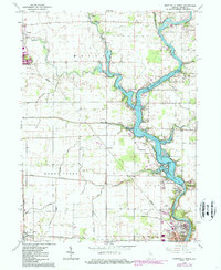
1962 Map of Monticello North
USGS Topo · Published 1986About this map
The Tippecanoe River carves through the landscape of White County, forming the recreational and residential heart of the region. By the early 1960s, the impoundment of Lake Shafer and Lake Freeman had transformed the river valley into a hub of leisure, anchored by the iconic Indiana Beach amusement area and the Tippecanoe Country Club. This era shows a community in transition, where old agricultural names like Guernsey and Norway sit adjacent to burgeoning shoreline developments like the Isle of Homes.
Find a feature on this map
48 named features on this map. Tap any name to fly to it.
Don’t see what you’re looking for? This feature index may not catch every label — zoom into the map to look around manually.
Map Details
Editions of this 1962 Monticello North Map
2 editions found
Other maps of this area

1953 · Danville
USGS Topo · 1:250,000

1955 · Danville
USGS Topo · 1:250,000

1956 · Danville
USGS Topo · 1:250,000

1962 · Buffalo
USGS Topo · 1:24,000

1962 · Monticello South
USGS Topo · 1:24,000

1962 · Monon NE
USGS Topo · 1:24,000

1962 · Brookston NW
USGS Topo · 1:24,000

1962 · Monon
USGS Topo · 1:24,000

1962 · Monticello North
USGS Topo · 1:24,000
1962 · Francesville
USGS Topo · 1:24,000