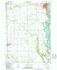
1962 Map of Monticello South
USGS Topo · Published 1987About this map
Lake Freeman and Lake Jefferson dominate the eastern landscape of this White County survey, formed by the Tippecanoe River and the Oakdale Dam. The waterfront is densely developed with recreation-oriented settlements and landings, including Walnut Gardens, Scarlet Oaks, and Golden Hill. To the west, the topography shifts to a geometric grid of agriculture and infrastructure, where the CSX and At & SF railroads intersect the landscape near Reynolds and Chalmers. Several rural burial grounds, such as Harvey and Phebus Cem and Bunnell Cem, are preserved among the fields of Union and Prairie townships. The local aviation history is marked by the White County Airport, while the growing community of Monticello shows institutional detail including the Courthouse, Roosevelt High Sch, and the local Library.
Find a feature on this map
52 named features on this map. Tap any name to fly to it.
Don’t see what you’re looking for? This feature index may not catch every label — zoom into the map to look around manually.
Map Details
Editions of this 1962 Monticello South Map
2 editions found
Other maps of this area

1953 · Danville
USGS Topo · 1:250,000

1955 · Danville
USGS Topo · 1:250,000

1956 · Danville
USGS Topo · 1:250,000

1962 · Brookston SW
USGS Topo · 1:24,000

1962 · Monticello South
USGS Topo · 1:24,000

1962 · Brookston NW
USGS Topo · 1:24,000

1962 · Monon
USGS Topo · 1:24,000

1962 · Delphi
USGS Topo · 1:24,000

1962 · Monticello North
USGS Topo · 1:24,000
1962 · Yeoman
USGS Topo · 1:24,000