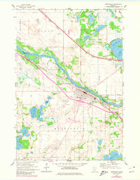
1961 Map of Monticello
USGS Topo · Published 1981About this map
The Mississippi River serves as the dividing line between Sherburne and Wright counties, carving a wide path through a landscape defined by glacial lakes and active rail corridors. The community of Monticello sits on the southern bank, characterized in this era by a cluster of civic landmarks including the Athletic Field, Riverside Cem, and Hillside Cem. North of the river, the town of Big Lake is surrounded by significant water bodies like Lake Mitchell and Ketter Lake, while the Northern Pacific Great Northern tracks run parallel to the water, connecting the small settlement of Salida to the broader regional economy. Away from the river, the terrain is pocketed with numerous Gravel Pits and smaller water features like Bertram Lake and Pelican Lake, illustrating the post-glacial topography of central Minnesota. Local history and genealogy researchers will find several well-defined burial grounds, such as St Henrys Cem and Helm Cem, providing clear spatial context for the area's rural development.
Find a feature on this map
48 named features on this map. Tap any name to fly to it.
Don’t see what you’re looking for? This feature index may not catch every label — zoom into the map to look around manually.
Map Details
Editions of this 1961 Monticello Map
3 editions found

Other maps of this area

1909 · Rockford
USGS Topo · 1:62,500

1953 · Stillwater
USGS Topo · 1:250,000

1955 · Stillwater
USGS Topo · 1:250,000

1958 · Stillwater
USGS Topo · 1:250,000

1958 · Rockford
USGS Topo · 1:62,500

1958 · Buffalo
USGS Topo · 1:62,500

1961 · Clear Lake
USGS Topo · 1:24,000

1961 · Big Lake
USGS Topo · 1:24,000

1961 · Silver Creek
USGS Topo · 1:24,000

1961 · Orrock
USGS Topo · 1:24,000