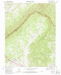
1967 Map of Montvale
USGS Topo · Published 1989About this map
Montvale serves as a primary settlement hub in this 1960s landscape, situated along the Norfolk and Western railway lines where the South Fork Goose Creek and Day Creek converge. The terrain is dominated by the steep slopes of the Jefferson National Forest, where the Blue Ridge Parkway traces the high ridgelines. This winding corridor features numerous scenic overlooks such as Harveys Knob Overlook and Mills Gap Overlook, marking the transition between the valley floor and the heights of Cove Mountain. Rural life is anchored by traditional landmarks like Walnut Grove Ch, New Prospect Ch, and Thomas Chapel. Evidence of historical industry persists in the western hills at Spec Mines, while the Appalachian Trail follows the crest near the county line between Botetourt and Bedford. The map reveals a community defined by its proximity to both major transportation infrastructure and the preserved wilderness of the national forest.
Find a feature on this map
68 named features on this map. Tap any name to fly to it.
Don’t see what you’re looking for? This feature index may not catch every label — zoom into the map to look around manually.
Map Details
Editions of this 1967 Montvale Map
Other maps of this area

1890 · Roanoke
USGS Topo · 1:125,000

1891 · Roanoke
USGS Topo · 1:125,000

1894 · Natural Bridge
USGS Topo · 1:125,000

1894 · Natural Bridge
USGS Topo · 1:62,500

1907 · Natural Bridge Special
USGS Topo · 1:62,500

1913 · Eagle Rock
USGS Topo · 1:48,000

1915 · Eagle Rock
USGS Topo · 1:62,500

1929 · Roanoke
USGS Topo · 1:48,000

1933 · Roanoke
USGS Topo · 1:62,500

1947 · Roanoke
USGS Topo · 1:250,000