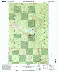
1996 Map of Monumental Mountain
USGS Topo · Published 2000About this map
Colville National Forest and Kaniksu National Forest dominate this northeastern corner of Washington, where the high ridges of the Selkirk Mountains meet complex drainage systems. The landscape is defined by its dramatic verticality, anchored by peaks like Molybdentite Mountain and Monumental Mountain. A rare ecological feature, Bunchgrass Meadows, occupies a high-elevation basin, serving as a critical water source for the surrounding wilderness.
Find a feature on this map
21 named features on this map. Tap any name to fly to it.
Don’t see what you’re looking for? This feature index may not catch every label — zoom into the map to look around manually.
Map Details
Editions of this 1996 Monumental Mountain Map
This is the sole edition of this map. No revisions or reprints were ever made.
Other maps of this area

1934 · Metaline
USGS Topo · 1:125,000

1942 · Metaline
USGS Topo · 1:125,000

1958 · Sandpoint
USGS Topo · 1:250,000

1963 · Sandpoint
USGS Topo · 1:250,000

1967 · Scotchman Lake
USGS Topo · 1:24,000

1967 · Metaline Falls
USGS Topo · 1:24,000

1967 · Monumental Mtn.
USGS Topo · 1:24,000

1967 · Helmer Mtn
USGS Topo · 1:24,000

1967 · Pass Creek
USGS Topo · 1:24,000
1967 · Orwig Hump
USGS Topo · 1:24,000