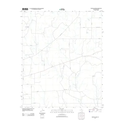
2012 Map of Moons Camp
USGS Topo · Published 2012About this map
Moons Camp occupies a central position in this corner of Cottle County, where the ranching heritage of West Texas is written across the landscape in a network of county roads and vital water sources. The terrain is defined by the drainage of several seasonal streams, including Shorty Cr and the winding Cottonwood Cr, which cut through the open country. The placement of essential infrastructure such as Red Tower Windmill and Divide Windmill highlights the importance of groundwater in this semi-arid environment. A dense grid of local thoroughfares, from Ranch Road 104 to Co Rd-411, connects isolated ranching interests, illustrating the persistent agricultural footprint in the Jacobs area during the early twenty-first century.
Find a feature on this map
23 named features on this map. Tap any name to fly to it.
Don’t see what you’re looking for? This feature index may not catch every label — zoom into the map to look around manually.
Map Details
Editions of this 2012 Moons Camp Map
This is the sole edition of this map. No revisions or reprints were ever made.
Other maps of this area

1954 · Lubbock
USGS Topo · 1:250,000

1954 · Plainview
USGS Topo · 1:250,000

1958 · Plainview
USGS Topo · 1:250,000

1967 · Dunlap
USGS Topo · 1:24,000

1967 · Triangle Ranch
USGS Topo · 1:24,000
1967 · Baker
USGS Topo · 1:24,000

1967 · Paducah
USGS Topo · 1:24,000

1967 · Moons Camp
USGS Topo · 1:24,000
1967 · Swearingen
USGS Topo · 1:24,000

1968 · Y Ranch
USGS Topo · 1:24,000