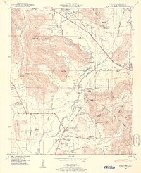
1948 Map of Moontown
USGS Topo · Published 1952About this map
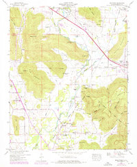
Moontown and the village of Gurley anchor this Madison County landscape during a period of transition in the late 1940s. The Southern Railway runs parallel to the Lee Highway in the north, while the southern terrain is defined by the steep rises of Keel Mountain and Drake Mountain. The Flint River meanders through the central valley, creating numerous riverine features such as Esslinger Island and Buffalo Island. The map is particularly notable for its documentation of early cultural boundaries, specifically the Old Cherokee Lands Boundary which cuts diagonally across the southern half of the quadrangle.
Find a feature on this map
78 named features on this map. Tap any name to fly to it.
Don’t see what you’re looking for? This feature index may not catch every label — zoom into the map to look around manually.
Map Details
Editions of this 1948 Moontown Map
5 editions found
Other maps of this area

1888 · Scottsboro
USGS Topo · 1:125,000

1888 · Huntsville
USGS Topo · 1:125,000

1892 · Huntsville
USGS Topo · 1:125,000

1892 · Scottsboro
USGS Topo · 1:125,000

1936 · New Hope
USGS Topo · 1:24,000

1936 · Meridianville
USGS Topo · 1:24,000

1936 · Moontown
USGS Topo · 1:24,000

1936 · Hollytree
USGS Topo · 1:24,000

1936 · Grant
USGS Topo · 1:24,000

1936 · Maysville
USGS Topo · 1:24,000