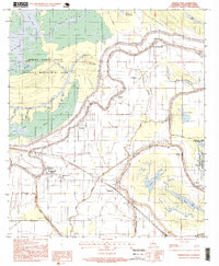
1996 Map of Moreauville
USGS Topo · Published 1999About this map
The floodplain of the Bayou Des Glaises defines the settlement patterns and agricultural layout of this corner of Avoyelles Parish. In the mid-1990s, the landscape remained deeply tied to its watercourses, with the primary towns of Moreauville and Hamburg positioned near the complex network of the Drainage Canal and Bayou Roseau. The map reveals a high density of religious and community landmarks, particularly churches like Sacred Heart Ch and Our Lady of Sorrow Ch, which reflect the region's cultural heritage. Large-scale conservation efforts are visible in the north and east, where the Spring Bayou State Wildlife Management Area and Pomme de Terre State Wildlife Management Area preserve the native Pomme de Terre Swamp and numerous oxbow features like Coco Lake and Lac Didier.
Find a feature on this map
50 named features on this map. Tap any name to fly to it.
Don’t see what you’re looking for? This feature index may not catch every label — zoom into the map to look around manually.
Map Details
Editions of this 1996 Moreauville Map
This is the sole edition of this map. No revisions or reprints were ever made.
Other maps of this area

1940 · Marksville
USGS Topo · 1:62,500

1941 · Voorhies
USGS Topo · 1:62,500

1948 · Bunkie
USGS Topo · 1:62,500

1952 · Lake Charles
USGS Topo · 1:250,000

1953 · Alexandria
USGS Topo · 1:250,000

1953 · Natchez
USGS Topo · 1:250,000

1954 · Lake Charles
USGS Topo · 1:250,000

1954 · Baton Rouge
USGS Topo · 1:250,000

1955 · Odenburg
USGS Topo · 1:62,500

1955 · Alexandria
USGS Topo · 1:250,000