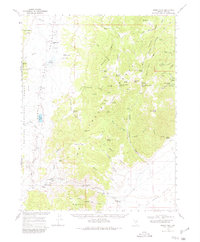
1968 Map of Morey Peak
USGS Topo · Published 1980About this map
Morey Peak and the high ridges of the Hot Creek Range dominate this Nevada landscape, where the Atomic Energy Commission cooperated in the 1968 mapping. The terrain transitions from the Little Fish Lake Valley in the west to Hot Creek Valley in the south, revealing a network of remote ranching outposts and springs. Significant local history is preserved in the presence of the Old Page Place, Old Dugan Ranch, and the Arrastra Ruins, the latter suggesting early ore processing in these canyons. A Kiln in Wood Tick Canyon and the Orange Lichen mine point to the area's small-scale industrial past. Navigating this high-desert environment relied on a series of trails and springs such as Pott Hole Spring and Lower Fandango Spring, which provided essential water for livestock and travelers alike.
Find a feature on this map
82 named features on this map. Tap any name to fly to it.
Don’t see what you’re looking for? This feature index may not catch every label — zoom into the map to look around manually.
Map Details
Editions of this 1968 Morey Peak Map
2 editions found

Other maps of this area

1956 · Tonopah
USGS Topo · 1:250,000

1959 · Tonopah
USGS Topo · 1:250,000

1962 · Tonopah
USGS Topo · 1:250,000

1967 · Lunar Crater
USGS Topo · 1:62,500

1967 · Moores Station
USGS Topo · 1:62,500

1967 · Blue Jay Spring
USGS Topo · 1:24,000

1967 · Upper Fish Lake
USGS Topo · 1:24,000

1967 · Palisade Mesa
USGS Topo · 1:24,000

1967 · Moores Station
USGS Topo · 1:24,000

1967 · Morey Peak
USGS Topo · 1:24,000