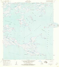
1955 Map of Morgan Harbor
USGS Topo · Published 1959About this map
Bayou La Loutre snakes through the marshy expanse of St. Bernard Parish in this mid-century hydrographic survey, illustrating a landscape defined by water and sediment. Situated where the marsh meets the open waters of Chandeleur Sound and Breton Sound, the area is a complex network of channels like Scow Pass and Jules Cutoff. Notable landmarks such as Comfort Island and Dry Bread Island rise just above the mean sea level, surrounded by shallow basins including Christmas Camp Lake and Treasure Bay. This survey reflects the coastal environment before significant late-20th-century erosion, documenting the exact positions of named points like Point Eliza and Codfish Point. The absence of roads or trails emphasizes the marine-dependent nature of life and navigation in Morgan Harbor during the 1950s.
Find a feature on this map
31 named features on this map. Tap any name to fly to it.
Don’t see what you’re looking for? This feature index may not catch every label — zoom into the map to look around manually.
Map Details
Editions of this 1955 Morgan Harbor Map
2 editions found
Other maps of this area

1893 · La Fortuna
USGS Topo · 1:62,500

1893 · Chandeleur
USGS Topo · 1:62,500

1895 · Bodreau
USGS Topo · 1:62,500

1935 · Morgan Harbor
USGS Topo · 1:31,680

1935 · Lake Athanasio
USGS Topo · 1:31,680

1935 · Mitchell Keys
USGS Topo · 1:31,680

1946 · Oak Mound Bayou
USGS Topo · 1:31,680

1946 · Lake Eugenie
USGS Topo · 1:31,680
1947 · Lake Athanasio
USGS Topo · 1:31,680
1947 · Lake Eloi
USGS Topo · 1:31,680