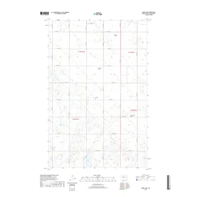
2017 Map of Mork Lake
USGS Topo · Published 2017About this map
Township Cem serves as a small but significant historical marker in this agricultural region of Ward County. This landscape is defined by the unique hydrology of the northern plains, where small prairie potholes and seasonal drainages such as Larsons Coulee and Gassman Coulee etch the terrain. The presence of Mork Lake in the southern portion of the sheet provides a rare permanent water body in a territory otherwise dominated by section-line roads like Co Hwy 13 and 54th Ave SW. The map reveals the rigid efficiency of the Public Land Survey System, with the intersection of four different townships visible through the boundaries of t155n r85w, t155n r84w, t154n r85w, and t154n r84w.
Find a feature on this map
20 named features on this map. Tap any name to fly to it.
Don’t see what you’re looking for? This feature index may not catch every label — zoom into the map to look around manually.
Map Details
Editions of this 2017 Mork Lake Map
This is the sole edition of this map. No revisions or reprints were ever made.
Other maps of this area

1928 · Minot
USGS Topo · 1:62,500

1948 · Burlington
USGS Topo · 1:24,000

1948 · Burlington
USGS Topo · 1:62,500

1948 · Minot NW
USGS Topo · 1:24,000

1949 · Minot NW
USGS Topo · 1:24,000

1950 · Des Lacs
USGS Topo · 1:24,000
1950 · Burlington
USGS Topo · 1:24,000
1951 · Burlington
USGS Topo · 1:62,500

1954 · Minot
USGS Topo · 1:250,000

1958 · Minot
USGS Topo · 1:250,000