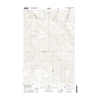
2014 Map of Morrell Mountain
USGS Topo · Published 2014About this map
Morrell Mtn and Monture Mtn anchor the high-elevation divide where the Flathead National Forest meets the Lolo National Forest. The landscape is defined by a dense network of mountain drainages, including Dunham Cr, Cottonwood Cr, and Black Canyon Cr, which flow through the timbered slopes of Missoula and Powell Counties. The southern portion of the map reveals the transition from steep peaks to the accessible waters of Cottonwood Lakes, served by the primitive corridor of Cottonwood Lakes Rd. Forest service routes like Spring Creek Rd and Wordworth-Seeley Lake Rd weave through the lower elevations, marking the modern intersections of recreation and forest management. This 2014 survey documents the persistence of these protected Montana woodlands and the topographical landmarks that guide travel through Youngs Pass and past Nome Point.
Find a feature on this map
32 named features on this map. Tap any name to fly to it.
Don’t see what you’re looking for? This feature index may not catch every label — zoom into the map to look around manually.
Map Details
Editions of this 2014 Morrell Mountain Map
This is the sole edition of this map. No revisions or reprints were ever made.
Other maps of this area

1902 · Ovando
USGS Topo · 1:125,000

1905 · Ovando
USGS Topo · 1:125,000

1955 · Choteau
USGS Topo · 1:250,000

1957 · Choteau
USGS Topo · 1:250,000

1958 · Choteau
USGS Topo · 1:250,000

1962 · Choteau
USGS Topo · 1:250,000
1965 · Woodworth
USGS Topo · 1:24,000

1965 · Morrell Mountain
USGS Topo · 1:24,000
1965 · Seeley Lake East
USGS Topo · 1:24,000
1965 · Salmon Lake
USGS Topo · 1:24,000