
1912 Map of Morris
USGS Topo · Published 1912About this map
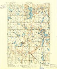
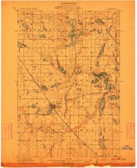
Morris serves as the regional hub at the convergence of multiple rail lines, including the Great Northern RR and the Northern Pacific RR. This 1912 survey captures the prairie landscape of Stevens County as it transitioned into a highly organized agricultural district. The State Agricultural School is prominently located on the outskirts of town, signaling the importance of scientific farming to the local economy. Beyond the town center, a dense network of numbered schoolhouses, such as School No 22 and School No 14, dot the townships of Fram and Darnen.
Find a feature on this map
56 named features on this map. Tap any name to fly to it.
Don’t see what you’re looking for? This feature index may not catch every label — zoom into the map to look around manually.
Map Details
Editions of this 1912 Morris Map
3 editions found
Other maps of this area
1910 · Chokio
USGS Topo · 1:62,500
1911 · Barrett
USGS Topo · 1:62,500

1911 · Herman
USGS Topo · 1:62,500
1912 · Chokio
USGS Topo · 1:62,500
1912 · Morris
USGS Topo · 1:62,500

1953 · Milbank
USGS Topo · 1:250,000

1953 · Saint Cloud
USGS Topo · 1:250,000

1957 · Saint Cloud
USGS Topo · 1:250,000

1958 · Milbank
USGS Topo · 1:250,000

1958 · Saint Cloud
USGS Topo · 1:250,000