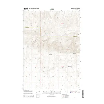
2015 Map of Morrison Canyon
USGS Topo · Published 2015About this map
Antelope Butte and Stagner Mtn anchor this high-elevation landscape along the border of Fremont and Hot Springs counties. The terrain is defined by a complex network of drainages and seasonal water sources, including Jergens Draw and Shearing Pen Draw. Significant grazing or ranching infrastructure is suggested by features such as Shearing Pen Spring and the presence of Gill Meadows. Transport through this pocket of the Wind River Basin is limited to routes like Burgess Rd, which navigates the lower elevations near Stagner Cr. The map reveals a land utilized for its scattered water points, from Nicholson Springs and Twin Springs to the larger Buffalo Lake, illustrating the critical role of water in the high desert of central Wyoming. This 2015 survey provides a clear view of the topographical transition from mountain slopes into the expansive Morrison Canyon and Morrison Meadows.
Find a feature on this map
23 named features on this map. Tap any name to fly to it.
Don’t see what you’re looking for? This feature index may not catch every label — zoom into the map to look around manually.
Map Details
Editions of this 2015 Morrison Canyon Map
This is the sole edition of this map. No revisions or reprints were ever made.
Other maps of this area

1950 · Mexican Pass SW
USGS Topo · 1:24,000

1950 · Bonneville SW
USGS Topo · 1:24,000

1951 · Mexican Pass SE
USGS Topo · 1:24,000

1951 · Boysen
USGS Topo · 1:24,000

1951 · Mexican Pass
USGS Topo · 1:24,000

1951 · Morrison Canyon
USGS Topo · 1:24,000

1955 · Thermopolis
USGS Topo · 1:250,000

1958 · Thermopolis
USGS Topo · 1:250,000
1958 · Mexican Pass SE
USGS Topo · 1:24,000
1958 · Bonneville SW
USGS Topo · 1:24,000