
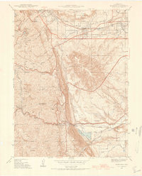
1938 Map of Morrison
USGS Topo · Published 1938About this map
The rugged gateway to the Front Range is captured here during the late 1930s, showing the early infrastructure of Red Rocks Park and its landmark Creation Rock. The landscape near Morrison and Golden reflects a transition from early resource extraction to public recreation and institutional development. Along Clear Creek, the Colorado School of Mines & Mine stands near the northern edge, while the State Military Reservation Camp George West occupies the flats below South Table Mountain.
Find a feature on this map
52 named features on this map. Tap any name to fly to it.
Don’t see what you’re looking for? This feature index may not catch every label — zoom into the map to look around manually.
Map Details
Editions of this 1938 Morrison Map
2 editions found
Other maps of this area

1899 · West Denver
USGS Topo · 1:125,000

1906 · Blackhawk
USGS Topo · 1:62,500

1939 · Golden
USGS Topo · 1:24,000

1941 · Arvada
USGS Topo · 1:31,680

1941 · Fort Logan
USGS Topo · 1:31,680

1942 · Morrison
USGS Topo · 1:31,680

1942 · Golden
USGS Topo · 1:31,680

1942 · Littleton
USGS Topo · 1:31,680

1942 · Ralston Buttes
USGS Topo · 1:24,000
1944 · Arvada
USGS Topo · 1:31,680