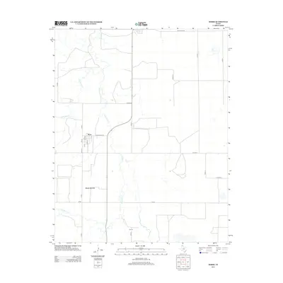
2012 Map of Morse
USGS Topo · Published 2012About this map
Morse and Morse Junction anchor this High Plains landscape, where the town site is organized by a small grid of streets including 5th St and 6th St. The area's hydrology is dominated by the winding paths of N Palo Duro Cr and S Palo Duro Cr, which cut through the level terrain typical of the Texas Panhandle. Near the southern edge of the survey, Lieb Cem remains a significant local landmark for genealogists and family historians. The transportation network is defined by a mix of state-maintained routes like Ranch Road 1775 and Fm-281 alongside a strict grid of county roads such as Co Road DD and Co Road A, illustrating the systematic rural development of Hutchinson County in the early twenty-first century.
Find a feature on this map
22 named features on this map. Tap any name to fly to it.
Don’t see what you’re looking for? This feature index may not catch every label — zoom into the map to look around manually.
Map Details
Editions of this 2012 Morse Map
This is the sole edition of this map. No revisions or reprints were ever made.
Other maps of this area

1953 · Stinnett Station
USGS Topo · 1:24,000

1953 · Pringle
USGS Topo · 1:24,000

1954 · Perryton
USGS Topo · 1:250,000

1954 · Amarillo
USGS Topo · 1:250,000

1958 · Perryton
USGS Topo · 1:250,000

1958 · Amarillo
USGS Topo · 1:250,000

1962 · Hansford
USGS Topo · 1:24,000

1974 · Morse
USGS Topo · 1:24,000
1974 · Pollard Creek NE
USGS Topo · 1:24,000

1974 · Hannas Draw East
USGS Topo · 1:24,000