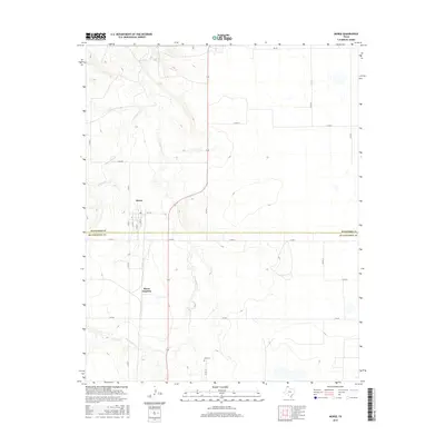
2016 Map of Morse
USGS Topo · Published 2016About this map
Morse and Morse Junction anchor this part of the Texas Panhandle, positioned near the boundary where Hansford Co meets Hutchinson Co. The landscape is defined by the winding paths of N Palo Duro Cr and S Palo Duro Cr, which carve through the high plains terrain. Local history and genealogy are anchored at Lieb Cem located to the south, while a network of rural routes including FM 281 and Co Rd 11 connect the outlying farmsteads. The street grid of Morse, featuring 6th St and S 2nd St, illustrates the concentrated settlement pattern of this agricultural region. The map captures the intersection of natural watercourses and established county lines in a sparsely populated but deeply rooted corner of Texas.
Find a feature on this map
21 named features on this map. Tap any name to fly to it.
Don’t see what you’re looking for? This feature index may not catch every label — zoom into the map to look around manually.
Map Details
Editions of this 2016 Morse Map
This is the sole edition of this map. No revisions or reprints were ever made.
Other maps of this area

1953 · Stinnett Station
USGS Topo · 1:24,000

1953 · Pringle
USGS Topo · 1:24,000

1954 · Perryton
USGS Topo · 1:250,000

1954 · Amarillo
USGS Topo · 1:250,000

1958 · Perryton
USGS Topo · 1:250,000

1958 · Amarillo
USGS Topo · 1:250,000

1962 · Hansford
USGS Topo · 1:24,000

1974 · Morse
USGS Topo · 1:24,000
1974 · Pollard Creek NE
USGS Topo · 1:24,000

1974 · Hannas Draw East
USGS Topo · 1:24,000