
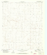
1970 Map of Morton NW
USGS Topo · Published 1973About this map
Armstrong serves as the primary named marker in this portion of the Texas Panhandle, a landscape defined by its grid-based agricultural development and subsurface water resources. The terrain is dotted with numerous Well and Wells sites, reflecting the intensive irrigation required for farming in Cochran County during the late 1960s. This pattern of water extraction, often accompanied by a local Tank, illustrates the engineering required to sustain agricultural life on the high plains. The map's network of improved and unimproved roads follows the rigid section lines of the Texas Water Development Board's survey system, providing a clear view of the rural infrastructure at the time of the 1970 field check.
Find a feature on this map
4 named features on this map. Tap any name to fly to it.
Don’t see what you’re looking for? This feature index may not catch every label — zoom into the map to look around manually.
Map Details
Editions of this 1970 Morton NW Map
2 editions found
Other maps of this area

1954 · Brownfield
USGS Topo · 1:250,000

1958 · Brownfield
USGS Topo · 1:250,000

1962 · Brownfield
USGS Topo · 1:250,000

1969 · Maple
USGS Topo · 1:24,000

1969 · Enochs
USGS Topo · 1:24,000

1969 · Lehman
USGS Topo · 1:24,000

1970 · Lingo
USGS Topo · 1:24,000

1970 · Bledsoe
USGS Topo · 1:24,000

1970 · Morton SW
USGS Topo · 1:24,000

1970 · Bledsoe NE
USGS Topo · 1:24,000