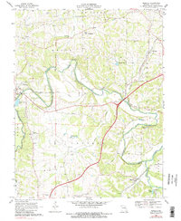
1969 Map of Moselle
USGS Topo · Published 1983About this map
The Bourbeuse River winds through the heart of this Franklin County landscape, creating dramatic loops that defined the early property boundaries and settlement patterns in Central and Union townships. During this era of transition in the late 1960s, the map documents significant infrastructure shifts, most notably the highway sections marked Under Const and 4 Lane that would soon reshape local travel. These modern corridors contrast with the historic rail lines of the Chicago Rock Island and Pacific and the St Louis-San Francisco, which served established communities like Villa Ridge and Moselle.
Find a feature on this map
36 named features on this map. Tap any name to fly to it.
Don’t see what you’re looking for? This feature index may not catch every label — zoom into the map to look around manually.
Map Details
Editions of this 1969 Moselle Map
3 editions found
Other maps of this area

1890 · Hermann
USGS Topo · 1:125,000

1901 · De Soto
USGS Topo · 1:125,000

1903 · O'Fallon
USGS Topo · 1:125,000

1903 · Sullivan
USGS Topo · 1:125,000

1946 · Union
USGS Topo · 1:62,500

1947 · St. Clair
USGS Topo · 1:62,500

1948 · Union
USGS Topo · 1:62,500

1948 · Washington
USGS Topo · 1:62,500

1948 · Augusta
USGS Topo · 1:62,500

1949 · Saint Louis
USGS Topo · 1:250,000