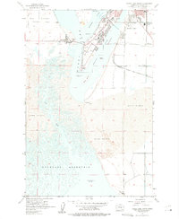
1956 Map of Moses Lake South
USGS Topo · Published 1975About this map
Potholes Reservoir and the southern reaches of Moses Lake dominate this mid-century landscape in the Columbia Basin. The map records a moment of significant hydrologic and suburban development, showing the expansion of Westlake and the establishment of Moses Lake State Park. Along the intricate shoreline, features like Parker Horn and Pelican Horn are separated by islands such as Crest Island and Goat Island, while the vast Sand Dunes to the south illustrate the unmanaged terrain before later irrigation projects fully transformed the area.
Find a feature on this map
31 named features on this map. Tap any name to fly to it.
Don’t see what you’re looking for? This feature index may not catch every label — zoom into the map to look around manually.
Map Details
Editions of this 1956 Moses Lake South Map
3 editions found

Other maps of this area

1912 · Moses Lake
USGS Topo · 1:62,500

1923 · Corfu
USGS Topo · 1:62,500

1923 · Wheeler
USGS Topo · 1:62,500

1924 · Othello
USGS Topo · 1:62,500

1925 · Wheeler
USGS Topo · 1:62,500

1951 · Corfu
USGS Topo · 1:62,500

1953 · Walla Walla
USGS Topo · 1:250,000

1953 · Ritzville
USGS Topo · 1:250,000

1954 · Soda Lake
USGS Topo · 1:24,000

1954 · Othello
USGS Topo · 1:62,500