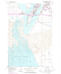
1956 Map of Moses Lake South
USGS Topo · Published 1978About this map
The expansive Potholes Reservoir and the southern reaches of Moses Lake dominate this mid-century landscape, illustrating the profound transformation of the Columbia Basin. The map details the intricate interplay of water and desert, where Crab Creek winds through extensive Sand Dunes before reaching the reservoir. Cultural development is concentrated at the northern edge, where the community of Westlake and several educational institutions, including the Chief Moses Jr H S and Peninsula School, signal the post-war growth of the region.
Find a feature on this map
31 named features on this map. Tap any name to fly to it.
Don’t see what you’re looking for? This feature index may not catch every label — zoom into the map to look around manually.
Map Details
Editions of this 1956 Moses Lake South Map
3 editions found

Other maps of this area

1912 · Moses Lake
USGS Topo · 1:62,500

1923 · Corfu
USGS Topo · 1:62,500

1923 · Wheeler
USGS Topo · 1:62,500

1924 · Othello
USGS Topo · 1:62,500

1925 · Wheeler
USGS Topo · 1:62,500

1951 · Corfu
USGS Topo · 1:62,500

1953 · Walla Walla
USGS Topo · 1:250,000

1953 · Ritzville
USGS Topo · 1:250,000

1954 · Soda Lake
USGS Topo · 1:24,000

1954 · Othello
USGS Topo · 1:62,500