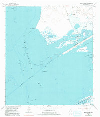
1952 Map of Mosquito Point
USGS Topo · Published 1991About this map
Matagorda Island Bombing and Gunnery Range occupies the southern reach of this coastal survey, where the barrier island separates the Gulf of Mexico from the interior bays. The mid-century landscape is defined by the Intracoastal Waterway, which cuts a straight path through San Antonio Bay toward Shoalwater Bay. This waterway was a critical piece of maritime infrastructure, maintained at a Project Depth 12 Feet to facilitate industrial traffic along the Texas coast.
Find a feature on this map
24 named features on this map. Tap any name to fly to it.
Don’t see what you’re looking for? This feature index may not catch every label — zoom into the map to look around manually.
Map Details
Editions of this 1952 Mosquito Point Map
Other maps of this area

1952 · Mosquito Point
USGS Topo · 1:24,000

1952 · Long Island
USGS Topo · 1:24,000

1952 · Mesquite Bay
USGS Topo · 1:24,000

1952 · Tivoli SE
USGS Topo · 1:24,000

1952 · Seadrift NE
USGS Topo · 1:24,000

1952 · Panther Point
USGS Topo · 1:24,000

1952 · Austwell
USGS Topo · 1:24,000

1952 · Seadrift
USGS Topo · 1:24,000
1952 · Panther Point NE
USGS Topo · 1:24,000

1953 · Beeville
USGS Topo · 1:250,000