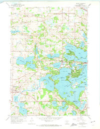
1958 Map of Mound
USGS Topo · Published 1974About this map
Lake Minnetonka and its intricate network of bays and islands dominate this mid-century portrait of western Hennepin County. The landscape is defined by the labyrinthine shoreline of the West Arm, Cooks Bay, and Halsted Bay, where prominent landforms like Phelps Island and Kings Point reveal the early residential and recreational footprint of the region. Inland, the transition from lakefront properties to agricultural and institutional land is evident, notably at the Jesuit Seminary near Parley Lake and the various youth retreats such as Christmas Tree Camp and Kingswood Camp.
Find a feature on this map
79 named features on this map. Tap any name to fly to it.
Don’t see what you’re looking for? This feature index may not catch every label — zoom into the map to look around manually.
Map Details
Editions of this 1958 Mound Map
4 editions found

Other maps of this area

1905 · Minnetonka
USGS Topo · 1:62,500

1907 · Minnetonka
USGS Topo · 1:62,500

1909 · Rockford
USGS Topo · 1:62,500

1953 · Saint Paul
USGS Topo · 1:250,000

1953 · Stillwater
USGS Topo · 1:250,000

1955 · Stillwater
USGS Topo · 1:250,000

1957 · Waconia
USGS Topo · 1:62,500

1958 · Stillwater
USGS Topo · 1:250,000

1958 · Victoria
USGS Topo · 1:24,000

1958 · Rockford
USGS Topo · 1:62,500