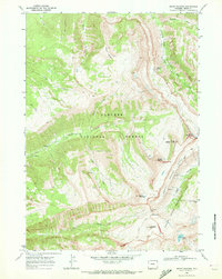
1968 Map of Mount Bannon
USGS Topo · Published 1972About this map
Targhee National Forest and Grand Teton National Park meet at the crest of the Teton Range in this detailed late-1960s survey. The landscape is defined by massive peaks including Mount Bannon, Mount Jedediah Smith, and Mount Meek, standing as sentinels over deep glacial carved features like Death Canyon and the Teton Crest Shelf. A complex network of drainage systems, such as North Fork Darby Creek and South Fork Teton Canyon, illustrates the high-altitude hydrology of the region, where water moves through notable subterranean features like Wind Cave and Ice Cave.
Find a feature on this map
37 named features on this map. Tap any name to fly to it.
Don’t see what you’re looking for? This feature index may not catch every label — zoom into the map to look around manually.
Map Details
Editions of this 1968 Mount Bannon Map
2 editions found
Other maps of this area

1899 · Grand Teton
USGS Topo · 1:125,000

1901 · Grand Teton
USGS Topo · 1:125,000

1943 · Driggs
USGS Topo · 1:62,500

1946 · Driggs
USGS Topo · 1:62,500

1955 · Driggs
USGS Topo · 1:250,000

1958 · Driggs
USGS Topo · 1:250,000

1962 · Driggs
USGS Topo · 1:250,000

1965 · Clawson
USGS Topo · 1:24,000
1968 · Granite Basin
USGS Topo · 1:24,000
1968 · Teton Village
USGS Topo · 1:24,000