
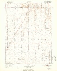
1951 Map of Mount Etna
USGS Topo · Published 1951About this map
The Salamonie River meanders across the northern portion of this Huntington County landscape, providing the primary drainage for a network of tributaries including Logan Creek, Richland Creek, and Pond Creek. This mid-century survey documents a rural agricultural region defined by small crossroad settlements and specialized institutions like the Star Commonwealth For Boys north of Wayne township. To the west, the community of Banquo sits along a prominent north-south road, while Mount Etna and Lancaster serve as local hubs near the river bends.
Find a feature on this map
26 named features on this map. Tap any name to fly to it.
Don’t see what you’re looking for? This feature index may not catch every label — zoom into the map to look around manually.
Map Details
Editions of this 1951 Mount Etna Map
2 editions found
Other maps of this area

1950 · Lagro
USGS Topo · 1:24,000

1950 · Andrews
USGS Topo · 1:24,000

1950 · Warren
USGS Topo · 1:24,000

1950 · Mount Etna
USGS Topo · 1:24,000

1951 · Andrews
USGS Topo · 1:24,000

1951 · Lagro
USGS Topo · 1:24,000

1952 · Warren
USGS Topo · 1:24,000

1952 · Majenica
USGS Topo · 1:24,000

1953 · La Fontaine
USGS Topo · 1:24,000

1953 · Muncie
USGS Topo · 1:250,000